Appendix I – Travel & Traffic Report
Gabi Cutayar, Fran Breslin, John Brockwell - Updated 01-08-20
CONTENTS OF THIS REPORT
INTRODUCTION
OBJECTIVES
CURRENT SITUATION & ISSUES
Traffic
Evidence/Monitoring data
Vehicle speeds
Vehicle volume/loads
Albury Village - The Street
Parish traffic
Tourist traffic
Developments adjacent to the Parish
Car Parking – including sites, capacity and electric vehicle charging points
Public transport - including bus routes and schedules.
Infrastructure - including pavements and footpaths
Carbon footprint and sustainable travel
MAIN ISSUES
ASPIRATIONS
INTRODUCTION
Albury Parish lies about 4 miles to the southeast of Guildford on the southern edge of the North Downs and entirely within the Green Belt and the Surrey Hills National Landscape (previously known as Surrey Hills ANOB) The Parish is rural in character with extensive open views and comprises the village of Albury located centrally in the Parish, and the dispersed hamlets of Farley Green, Little London, Albury Heath, Brook to the south, and Newlands Corner in the north with its well-known viewpoint. Parts of Farley Heath and Albury Heath are subject to an open access agreement which means these areas are designated for walking and outdoor recreation are permitted. Albury is defined as a ‘Small Village’ and Farley Green as a ‘Loose Knit Hamlet’.
The Parish is referred to as a peaceful and beautiful place and this area of the Surrey Hills AONB is considered to be the ‘playground’ for the urban areas of Guildford; walking and cycling being popular pursuits. The Albury Estate operate a number of recreational fisheries along the Tillingbourne. There are extensive footpaths and bridleways throughout the Parish.
The village retains a pub (The Drummond Arms) and local shop/post office as well as St Peter’s and St Paul’s Church. An enhanced Village Shop has recently been provided adjacent to the Drummond Arms. Services in the other settlements are limited. The William IV pub is located in Little London.
Albury Village is also home to Albury Estate Fisheries; a private business.
The local road network comprises largely unimproved rural B-class roads and unclassified country lanes as well as part of the A25 from the junction at A248, up the hill to Newlands Corner and on to the Guildford Manor Hotel and Spa. The other A road in the Parish is the A248 which begins at the junction with the A25 and proceeds through the centre of Albury Village. This road is referred to as the ‘Guildford southern by-pass’. There is concern about the increasing volume of traffic using the A248 and in other areas of the Parish. Given the limited employment opportunities within Albury Parish, most people commute to work outside the neighbourhood area.
Guildford Lane is the road link between Guildford and Albury. The passing places are difficult to maintain and there is regular flooding on the bend at White Lane Farm. The blind corner and the build-up of silt on the approach to White Lane farm from Albury, makes this a dangerous part of the road.
There is a considerable increase in the number of road cyclists in the Parish.
There is no railway station in Albury Parish. Railway services are located at Chilworth (1.4 miles) and Clandon (4.4miles) with routes to Guildford, Dorking and London. The bus network is limited and infrequent.
There is a speed problem with traffic.
The 85Th percentile is defined as “the speed at or below which 85 percent of all vehicles are observed to travel under free-flowing conditions past a monitored point.” Another way to consider this is the speed at which only 15% of traffic violate on average. The 85Th percentile has increased from 35mph in 2012 to 42mph in 2020, and the average speed from 30mph to 36mph in the same period. The basic fact is, over the last year, 88% of vehicles entering the village from the A25 direction exceed the 30mph speed limit, some by a considerable margin.
OBJECTIVES
This report aims to outline the issues and develop an aspirational proposal to define further opportunities for:
traffic calming
car parking in the Parish
promotion of sustainable travel
improved traffic management throughout the Parish, particularly at the A248 junction with the A25, The Street, Park Road and New Road.
CURRENT SITUATION AND ISSUES
- Traffic
Monitoring data has been received from a Vehicle Activated Speed (VAS) camera on The Street in Albury located outside Weston House. It records the speed and volumes of traffic entering the village from Sherbourne and New Rd.
The following reports have been used as evidence (see Appendix):
- The Albury Extended Speed_30 Nov-7 Dec12 (not VAS)
Albury VAS_23Mar-28Apr19
Albury VAS_24Apr-29Jun19
Albury VAS_16Feb-2Mar20
Albury VAS_2Mar-15 Mar20
Albury VAS_26Mar-5Apr20
- Vehicle Speeds
From the VAS data available as per the above reports in 2019/2020, we can deduce the following:
For at least the past year, 81% of vehicles proceeding towards Chilworth travel at 40mph and above
Speeds are generally higher in the hours before 07:00 and between 17:00 and 19:00.
Traffic issues have been regularly raised by the community especially on The Street in the centre of the Village.
In addition, the houses adjoining the Village Hall on the north side of The Street have no pavement in front of them. Residents in these houses park their cars on the opposite side of the Street creating a narrowing of the road. Cars approaching from the A25 need to ‘run the gauntlet’ up to the Village Store or wait until traffic approaching from Chilworth has come through the ‘single lane’ area created by the cars parked on the south side of the road.
The junction at A25 and A248 remains an accident ‘blackspot as vehicles from Shere can do in excess of 50 miles per hour as they approach the junction. In addition, vehicles attempting to cross the A25 onto the A248 need to be mindful of not only those vehicles approaching on the A25 but also those on the short access road where vehicles are supposed to give way to traffic from the A25.
Over the last 5 years, accidents have occurred:
Trodds Lane / A25 junction: 7
Newlands Corner amenity site entrance / exit with A25: 2
Shere Rd (A25) between Newlands Corner and dual carriageway (A248 junction): 26
The weekend traffic exacerbates the issue and the growing popularity of the Silent Pool premises and walking areas around result in significant traffic volume and parking issues. We need more information about speed on roads / lanes around Farley Heath Road, Park Road, New Road.
In relation to The Street, Albury, consideration has been given to the implementation of a 20 mph local speed limit.
Surrey County Council Policy states the following;
“Within the latest central government guidance issued by the Department for Transport (Circular 01/2013) there is greater encouragement for local authorities to introduce more 20 mph schemes (limits and zones) in urban areas and built-up village streets that are primarily residential, to ensure greater safety for pedestrians and cyclists.
Circular 01/2013 emphasises that research into signed-only 20 mph speed limits shows that they generally lead to only small reductions in traffic speeds. Signed- only 20 mph speed limits are therefore most appropriate for areas where vehicle speeds are already low. If the mean speed is already at or below 24 mph on a road, introducing a 20 mph speed limit through signing alone is likely to lead to general compliance with the new speed limit.
Where the existing mean speeds are above 24 mph then a 20 mph scheme with traffic calming measures (known as a 20 mph zone) will be required. Research has shown that 20 mph zones with traffic calming measures have been very effective in reducing speeds and casualties, may encourage modal shift towards more walking and cycling and may result reductions in traffic flow on the road as vehicles choose alternative routes. However traffic calming measures are more expensive and are not always universally popular.
It is possible to implement 20 mph schemes that consist of a combination of physical features (where existing speeds are high), and signs alone (where speeds are already low) on different sections of the same road.
Research has shown that mandatory variable 20 mph speed limits that apply only at certain times of day (using an electronic sign) are not very effective at managing vehicle speeds. Surrey police do not support 20 mph speed limits that are not generally self enforcing. The electronic variable message signage that would be required for a mandatory variable 20 mph speed limit would also place an additional maintenance burden on the county council for little benefit. Therefore Surrey County Council will not support the use of new mandatory variable 20 mph speed limit”.
It is noted that Surrey Country Council propose to implement a 20 mph speed limit in the centre of Reigate and included in that area is the A25 High Street and A217 Bell Street. This is due to be completed by Spring 2021. The effectiveness of this speed limit will be considered by the working group at a later date but the current issue for the Parish is that the speed limit is too high in The Street.
Albury Village has chosen to have no streetlights and is designated as a Dark Sky area which makes the implementation of many traffic calming measures very difficult.
- Vehicle Volume/Loads
From the VAS data from the Street available as per the above reports in 2019/2020, we can deduce the following:
The number of vehicles per day moving in both directions has increased approximately 25% from March 2019 to March 2020.
Breakdown of vehicle type:
Car: 85%
Lorry: 10%
Long vehicles: 5%
We need more information about traffic volume on Park Road and New Road.
- Albury Village – The Street (Village Store and Drummond Arms location)
The enhanced Village Shop has recently been provided adjacent to the Drummond Arms. This has further increased destination traffic which park in the main along the road outside the shop despite parking facilities located in the Drummond Arms parking area.
- Parish traffic
The majority of residents living outside the Albury settlement area cannot access local shops, schools, doctor’s surgery, employment or community resources without the use of a private car. The majority of traffic using the listed ‘problem locations’ (see the section on Developments - adjacent to the Parish, below) are travelling through the Parish accessing Guildford, the M25 and Woking, Clandon and Effingham rail stations. Guildford Borough Council have identified a general lack of sustainable travel options in rural areas and associated road safety issues, particularly for pedestrians and cyclists.
- Tourist traffic
The local area is extremely popular with day visitors especially during weekends. Newlands Corner, Silent Pool and other car parks are often at capacity and cycling, both on and off road has increased in popularity. New housing developments such as Gosden Hill Farm will bring additional people into the Parish to walk, cycle, visit pubs and restaurants and enjoy the green space. The Surrey Hills AONB Management Plan seeks to encourage and facilitate sustainable local tourism whilst raising awareness of the impact traffic has on the Surrey Hills. This plan supports the need to provide safe and convenient non-motorised access by working with rail and bus operators and through initiatives to promote walking, cycling and horse riding for people who live in, work in and visit the Surrey Hills and to ensure that the loss of any existing footpaths and cycle paths will be strongly resisted.
Edgeley Park: 286 holiday lodges situated in Farley Green. Edgeley Park is noted as it is deemed a holiday village not for permanent residency. Residency rates remained high during COVID-19 lockdown with significant vehicle movement especially during the morning rush hour. Vans and liveried trade vehicles make up much of the traffic entering and exiting the site.
- Developments (Adjacent to the Parish)
The housing need figure for Guildford and adjacent boroughs has calculated the following: Guildford Borough requires 10,678 dwellings to be completed by 2034, Waverley Borough 11,210 by 2032 and Mole Valley 6,735 by 2033. This equates to 562, 590 and 449 dwellings per annum respectively as identified in each borough’s Strategic Housing and Economic Land Availability Assessment.
The development which is most likely to impact on Albury Parish is Dunsfold Park Garden Village. 1,800 new houses (1 to 6 bed) to be built before 2031 with the first 50 completed in 2022. Although some 7 miles from the Parish, the main access to the Garden Village will be via the A281. Commuters accessing the M25 are able to bypass the often-congested A281 through Guildford via the A248 and A25. The A248 and A25 junction has already been identified as a problem in the Parish.
Plans for an additional 350 houses in Cranleigh, Ewhurst and Alfold will mean additional traffic using Pitch Hill/ Hound House Road and ultimately Park Road/New Road to access the A3 / M25 and rail stations. Possible further traffic calming measures in Shere Village will encourage vehicular traffic onto Park Road where they will then also be funnelled towards the A248/ A25 junction.
Hornhatch Farm, Chilworth, if approved, will add a further 80 family homes directly accessing the A248.
There are several other large developments within 5 to 7 miles of the Parish which are likely to create additional traffic movement for leisure purposes rather than commuting to work. The Guildford and Waverley Local Plans all recommend the use of the AONB for leisure use by new home owners in their justification to build. These include the building of 1,800 homes at Gosden Hill Farm some 3.5 miles from Newlands Corner,1000 new homes at Slyfield, 550 new homes at Garlicks Arch, Send Marsh Road and an additional 400 homes in and around Horsley.
Wisley Airfield was purchased in March 2020 by Taylor Wimpey. A previous garden village was ruled against in 2017. Any large-scale development in this area will impact on local leisure traffic and tourism. The Guildford Local Plan has designated this site for 2250 new homes.
The combined sum of new build properties with traffic movements likely to impact Albury Parish for either commuter or leisure purposes is 8230. This excludes the impact of any new development in Mole Valley which has yet to be confirmed. This development is scheduled to happen before the end of the Local Plans in 2034, with no additional investments in infrastructure commitments for roads until the end of this period and none designated for Albury Parish. During this period we can expect additional traffic from construction vehicles and delivery vehicles with the growth of online shopping.
A New Park and Ride site is planned at Gosden Hill Farm urban extension (from GBC Transport Strategy 2017)
Based on the above information and the fact that 86% of households in Guildford Borough have one or more car or van, the locations that will be affected are as follows
A248 junction with the A25.
The Street, Albury
Farley Heath Rd
Park Road/New Road.
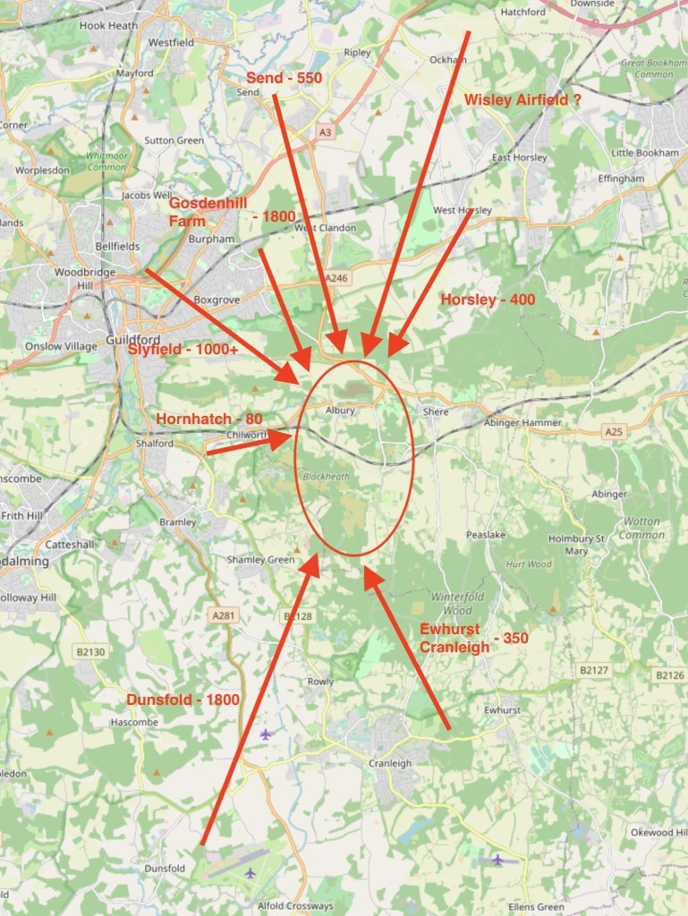
Locations of Developments Adjacent to The Parish
- Car parking
Sites
There are limited car parking facilities within the Parish and most available car parks are associated with a specific destination such as the car Parking at the Drummond Arms, at William IV, Silent Pool and Newlands Corner. The only car park offering toilet facilities is the one at Newlands Corner.
Car parking hotspots where parking either exceeds capacity or vehicles are parked in areas not originally intended for multiple vehicle use include:
Newlands Corner
Silent Pool
The Street outside the Village Store*
*There is provision for parking for these houses in the Village Hall car park, however residents need to pay for this parking. The narrowing of the road in this area as a result of cars parking along The Street acts as a natural traffic calming obstruction.
The Village Hall car park is frequently full which prevents resident parking. Rural car parks are too far away to be of use for access to Albury Village.
Capacity
During the course of 2018/19, the volume of vehicles making use of the Newlands Corner car park has increased dramatically and the car park is often over capacity. There are 200 parking spaces at Newlands Corner and as of March 2020, they are free of charge with no plans to reinstate parking charges. Excess vehicles have made use of the Plucky Pheasant Café car park across the road despite this being reserved for patrons.
The Silent Pool car park has become a major source of concern both for Albury Parish residents and passing traffic. People have taken to parking along the roadside in front of the Easter houses (north side of the road), in the layby on the approach from Shere and also on the central island of the dual carriageway. This has been raised with Guildford Borough Council and local police who have now put out traffic cones on the verges and island to prevent parking.
Currently the Albury Vineyard parking is largely closed but once back in normal operating mode, i.e. tours and tastings, the ample available parking is satisfactory. The problem remains with ad hoc visitors to the Silent Pool Gin Distillery, Mandira and Norbury Cheese, as none of these businesses have any available parking other than Silent Pool Car Park. Car park capacity here is exacerbated when adding in in people wishing to use the Car Park as a base to start a walk.
Before any further development is permitted at Sherbourne Farm a traffic management solution must be sought, to include parking and the necessity for HGVs to reverse out onto the A25 following deliveries.
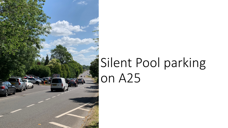
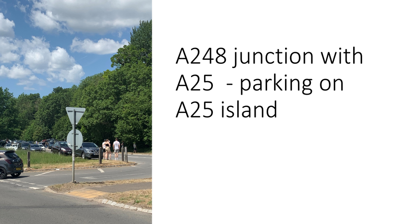
Silent Pool parking on A25 A248 / A25 parking on central reservation
Electric vehicle charging points
There are currently no electric vehicle charging points at any of the local car parks within the Albury Parish. In addition, it is unlikely that the Parish could provide sufficient capacity for high-speed charging points.
- Public transport
Bus Routes
There are a few bus services that service the Albury Parish run along The Street through Albury Village. The bus stop is located outside the Drummond Arms pub.
No 32: Guildford to Strood Green (Stagecoach in Hants and Surrey)
No 32: Guildford - Dorking – Strood Green – Redhill (Compass Travel)
No 525: Albury to Cranleigh (Carlone Buses)
No 545: Walliswood – Guildford (Carlone Buses)
No 625: Guildford – George Abbotts School – St Peters School (Compass Travel)
Bus stop locations include:
Park gates
Silent Pool
Surrey Hills
The Drummond
Water Lane
Weston Lodge
The cost of bus travel between Albury and Guildford is between £2-£4.
Schedules
At peak times, no 32 bus runs every 30 minutes at 25 past and 5 minutes to the hour decreasing on weekends to every 1 – 2 hours. The other buses appear to operate on specific days only and at specific times once during the day. Bus routes do not accommodate Parish residents who wish to travel to the doctor’s surgery, nor do they operate at times suitable for travel to schools outside the Parish.
The Guildford Local Plan discusses bus corridors to universities and additional train stations (potentially Merrow).
Whilst bus routes in Albury Parish are limited, provision of additional routes and services may be detrimental to the rural nature of the Parish.
The closest Park and Ride is situated in Merrow.
- Infrastructure
Pavements and Footpaths
Areas of concern include:
- The Street, between the village hall at Albury Memorial Library to the east and 25 Waterside Cottage to the west, only has a footpath on the south side. Narrowing of the road means there is no pavement in front of the houses and cars pass the house walls with often less than 1 foot or so to spare
North Downs Way road crossing at Newlands Corner: crossing the road on foot or bicycle is treacherous both with traffic speed and visibility
Farley Green to Albury Village – there is no footpath access along/parallel to New Road
Footpath that crosses Sherbourne near the Catholic Apostolic church has blind visibility of traffic approaching from both Albury and the A25 because of high hedges and is a danger to pedestrians and motorists. This is a route regularly used by Duke of Edinburgh award students.
- Carbon footprint and sustainable travel
The lack of linked-up public transport and the nature of some of the local roads enforce a level of car dependence in the Parish. Narrow lanes, a lack of pavement space and the fact that Surrey has a higher level of car ownership than any other county makes sustainable travel a challenge. The Parish is situated within the Surrey Hills Area of Outstanding Natural Beauty and its management plan aims to raise awareness of the impact traffic has on the Surrey Hills. The Parish will aspire to work with the Surrey Hills AONB, Guildford Borough Council and Surrey County Council to improve access and connections to sustainable transport. Support will be given to any proposals that improve and extend the existing footpath and cycle path network as well as the connections to other sustainable transport options such as rail and bus routes.
Without access to safe, convenient and non-motorised transport to and from the Parish, the majority of residents will remain car dependent. With 86% pf people in Surrey owning one or more vehicles, we need support as a Parish to achieve our goals.
- Noise pollution
The Parish is a popular destination for motorbikes. There has been a significant increase in the number of motorbikes which have had their silencers removed, creating noise disturbance to local residents, particularly those in the Street in Albury where the houses abut the A248. Albury Parish Council should seek to monitor sound volume and work with the police and other local parishes to reduce noise pollution caused by motorbikes. In the UK, the noise limit for a motorbike is set at 80dB, with an extra 6dB added to account for mechanical noise. The police have authority to enforce this under the Road Vehicle (Construction and Use) Regulations 1986.
MAIN ISSUES
The Parish faces traffic and transport issues that need to be addressed to ensure a sustainable way forward as part of the Neighbourhood Plan:
- Traffic
Traffic volume and speed through Albury Village and along Park Road/New Road increases year on year.
Weekend additional traffic, with significant influx from outside the Parish, includes more walkers, cyclists, motorbike enthusiasts (noise pollution during the days), horse riders, etc. all competing for the same resources.
The nature and volume of commuter and rush hour traffic as well as commercial and weekend traffic (motor bikes and lorries/long vehicles) on our often narrow and sunken lanes contribute significantly to noise pollution in the area
The Street is designated an A road which is defined as a major road that is narrower than a motorway but wider and straighter than some B roads. Rural A roads are considered far more dangerous than motorways.
There is a problem with excessive noise caused by motorbikes.
- Car Parking
Newlands Corner often overcapacity and location of access points dangerous due to poor visibility and traffic speeds.
Silent Pool is also often overcapacity and location of access points dangerous due to poor visibility and traffic speeds.
Parking in the area outside the closed Landfill facility is unlikely to be a solution as people will not walk from there to the businesses at Silent Pool because to do so will involve crossing two lanes of the A25 in each direction and the inherent danger that involves, and also remove possible development space for industrial use of the area
- Public transport
- Current bus routes do not link up to railway services or Park and Ride facilities and frequency does not meet community needs.
- Infrastructure
- Lack of infrastructure, in particular pavements which makes getting around on foot or cycling more difficult.
- Carbon footprint and sustainable travel.
No electric car charging points within the Parish
The key climate and sustainability vulnerability for the Parish is enforced car dependency
As previously stated, the lack of connectivity within the Parish and with local towns, stations and park and ride venues is the biggest sustainability issue, for residents and visitors.
ASPIRATIONS
- Traffic Calming
Areas for consideration:
The approach to the A25/A248 junction
The Street in Albury Village
Potential 20mph area between Weston Farm and Old Mill
There is a need for significant traffic calming or consideration for a bypass of the Village for through traffic.
The issue has been tackled on several different occasions and the traffic speed and volume continues to increase. Further measures will need to be considered. SCC have very limited budgets and traffic calming measures are expensive, avenues for funding will need to be pursued.
VAS Camera:
The Albury Parish Council has purchased a VAS camera. Potential placement locations rotating on a monthly basis:
On approach to the Village opposite the ponds outside the Estate offices
Entry to the village from Chilworth side at entrance to Weston Farm
Speed enforcement cameras:
Provision of mobile speed enforcement cameras at several locations in the 30mph zone. This should include those used in police vans and hand held devices run by local residentts groups.
Reclassification of A road:
Investigate the possibility of reclassifying the A248 to another type of road which will allow for installation of relevant traffic calming measures.
Restriction of heavy goods vehicles
Explore how we can make use of Traffic Regulation Order (in accordance with the Road Traffic Regulation Act 1984) where weight restrictions can be imposed for structural or for environmental reasons. The restriction prevents large vehicles from using inappropriate roads, routes and areas in order to:
· Reduce danger to pedestrians and other road users – narrow pavements in Albury Village and narrow roads with no shoulder
· Prevent damage to buildings, roads and bridges – houses abutting The Street between the Village Hall and the Drummond Arms.
· Preserve the character, amenity and environment of an area.
- Car Parking
Restriction of any further development at Silent Pool without sufficient provision for appropriate parking and traffic management.
There is a requirement for parking for residents in the central part of the Street. They are currently permitted to park at a cost in the Village Hall car park. This also accommodates businesses. There is a requirement for additional car parking as this is not sufficient. The following sites should be considered: On the land adjoining Albury House which has been refused for housing development on several occasion, at appeal, on the land next to Albury House, and Albury Bowls club.
- Public transport
It is noted that the Parish has an aspiration to move towards a more sustainable transport system with improved public transport and less reliance on the car but that this needs to be achieved working with other partners locally and nationally. The recent pandemic has shown that car use can be reduced but that there is a need for improved infrastructure links within the Parish.
- Proposed improved bus links to Guildford and Clandon train stations (Guildford East and West)
- Infrastructure
- Provision of footpath along the side of New Road
- Carbon footprint and sustainable travel
Installation of 2x electric car charging points in Drummond Arms and Silent Pool car parks
Any new dwellings, other than residential care homes, should provide a cycle storage unit with capacity for at least one bicycle per bedroom.
- Noise reduction
- The Parish Council to monitor road noise, particularly motorbikes and work with the police and other local parishes to reduce this especially in Albury village.
It is our ambition to work effectively with partners to ensure that there is appropriate infrastructure in place for the existing community and to move towards sustainable transport systems with improved public transport and less reliance on the car.
Locations have been identified for the charging of electric vehicles and consideration will be given to specific parking for low and ultra-low emission vehicles at locations such as Newlands Corner.
The loss of any existing public paths will be resisted, and current routes will be improved and developed where possible.